SMT AYEESHA TASNEEM, RESEARCH OFFICER

SMT.D.NAVEENA, ASSISTANT RESEARCH OFFICER
|

SRI.S.MALLESH, ASSISTANT RESEARCH OFFICER
|

SRI.B.ABHINAY, RESEARCH ASSISTANT
|

SMT.D.A.ARUNA SREE, RESEARCH ASSISTANT
|

SMT.M.SHIROMANI, RESEARCH ASSISTANT
|
One of the most important problems in the development and maintenance of storage reservoirs is the loss in storage capacity due to silting, resulting from deposition of stream born sediment. As storage reservoirs are subject to silting, sedimentation of reservoirs is a matter of great concern to all water resources developing authorities. The decrease in the storage capacity prevents the reservoir from supplying the services for which it was designed, thus disturbing the economic life of community which it serves. Systematic capacity surveys of reservoirs are thus inevitable to ascertain the situation and suggest suitable remedial measures. The Sedimentation Surveys (Hydrographic Surveys) are necessary to get realistic estimate of rate of siltation of reservoirs and to provide reliable criteria for studying the implications of annual loss of storage capacity over a definite period. This data will also be utilised to formulate guidelines relating to the provision of silting in the design of future reservoirs. Keeping in view the importance of the Capacity Surveys in reservoirs for determining the rate of sedimentation, Government has accorded permission for setting up full-fledged division under control of A.P.Engineering Research Labs. Earlier, one sub-division headed by an Assistant Research Officer has been working since 1975. In view of the large number of medium irrigation projects in the state and inadequacy of the staff of the sub-division to cover all the reservoirs within a reasonable time and also on the advice of the advisory committee of CBIP for Research and Development, the sedimentation division headed by Research Officer with four sub-divisions with the supporting staff was sanctioned by the Government and this division is functioning from the date with some minor changes in the sub-divisions. Since the inception of Sedimentation division, many Medium Irrigation Projects were covered by conducting Hydrographic Surveys. Hydrographic Surveys of all Major reservoirs like Sriram Sagar, Nizam Sagar, Nagarjunasagar Project, Srisailam Project etc in Telangana and Andhra Pradesh were successfully completed. This division has also successfully conducted the Hydrographic Surveys in Tungabhadra Reservoir, which was a joint venture of Andhra Pradesh and Karnataka States. Due to these results, the due share of Andhra Pradesh has been increased. Today the Sedimentation Division deals with conducting Hydrographic Surveys of Major & Medium Irrigation reservoirs to assess their capacity, rate of siltation, which helps in reservoir operation and to undertake remedial measures in advance. This division undertakes the Hydrographic Surveys with non-plan funds from Government of Telangana and deposited funds from field authorities of I & CAD Department. The services of this division are also used in model studies of the reservoirs and hydraulic structures, Inter State disputes, and in the evaluation of safety of dams. 2. INFRASTRUCTURE FACILITIES AVAILABLE: Two types of Hydrographic Surveys are being carried out by this division. The Conventional method is used for conducting Hydrographic Survey in Medium Irrigation Reservoirs and the Integrated Boat Mounted Bathymetric System (IBS) method is used for conducting Hydrographic Survey in Major Irrigation Reservoirs. The equipment used during the Hydrographic Survey by Conventional Method and IBS Method are as shown below.
3. TESTING PROCEDURES/ METHODS ADOPTED: There are two methods adopted by this division for carrying out the Hydrographic Surveys i.e. Conventional Method and IBS Method. The details are as follows:
Knowledge of the shape of the water spread at or above the level at which the survey is conducted, remains a pre requisite towards a meaningful orientation of the range lines. Such a water spread area is obtained from the Satellite Imagery extract prepared by the National Remote Sensing Agency, Hyderabad for the current water level. The end coordinates of the range lines are then incorporated in the imagery along with the field data and the data is processed in the laboratory for drawing grid maps, contour maps, and wire frame maps using the surfer software. For computation of capacity of reservoir, areas of different contours are computed using the surfer software from Lowest Contour to PWL. The capacity is then worked out using the following prismoidal formula. V = H/3(A1+A2+Ö(A1*A2 ) Where V = Volume i.e., capacity in M.Cum H = Interval between two successive contours in metres A1 = Lower contour area in M.sqm A2 = Upper contour area in M.sqm Finally the capacity table as per hydrographic survey should be tabulated.
After completion of survey work, the data is exported to surfer software for generation of grid, contour plans, surface map and shaded relief map. For computation of capacity of reservoir, areas of different contours are computed using the surfer software from Lowest Contour to PWL. The capacity is then worked out using the following prismoidal formula. V = H/3(A1+A2+Ö(A1*A2 ) Where V = Volume i.e., capacity in M.Cum H = Interval between two successive contours in metres A1 = Lower contour area in M.sqm A2 = Upper contour area in M.sqm Finally the capacity table as per hydrographic survey should be tabulated. 4. LIST OF IS CODES:
5. SCHEDULE OF RATES: The same Standard Schedule of Rates (SSR) adopted by the Irrigation & CAD Department for the corresponding financial year is also adopted here. 6. PAST ACHIEVEMENTS OF THE LABORATORY:
7. IMPORTANT WORKS DONE: Since establishment, Sedimentation division conducted hydrographic surveys periodically in 8 Major Reservoirs and more than 60 Medium reservoirs in Telangana and Andhra Pradesh. The Hydrographic survey of Major reservoirs are conducted by TSERL using highly sophisticated equipment namely Integrated Boat Mounted Bathymetric System equipment (IBS) which was procured under the Hydrology Project Phase-I during the financial year 2001-02. Since procurement, the equipment was used in all major reservoirs in combined Andhra Pradesh state, for estimating the capacity and Rate of Sedimentation in Reservoirs. Previously under Hydrology Project Phase II (HP-II), hydrographic surveys in four Major Reservoirs namely 1) Priyadarshini Jurala Project (2011) 2) Nizamsagar Reservoir (2013), 3) Kaddam Reservoir (2013) & 4) Sriram Sagar project (2014) were completed using IBS equipment. The hydrographic surveys in Medium Reservoirs are being conducted using conventional method. In the last 5 years, the hydrographic surveys of Wyra Reservoir, Hussainsagar Lake, Ookachettivagu Reservoir, Singotam Balancing Reservoir and Nallavagu Reservoir were completed. 8. FIELD VISITS: All the hydrographic surveys involve visiting the reservoir, gathering the field data and processing in the laboratory. Hence all the hydrographic surveys mentioned above involve camping at the project site. |
REMOTE SENSING LABORATORY
1. INTRODUCTION
The Remote Sensing Laboratory was established in the year 1986 vide the G.O.Ms.No.62 Dt: 11.2.1986 Irrigation (IRR VII) Department to cater the needs of Irrigation Department. This Lab is taking up the works like estimation of capacity of reservoir and the rate of sedimentation, identification of ground water potential zones, crop land acreage estimation under command areas and other related problems for water resources development and management studies.
2. INFRASTRUCTURE
Previously analysis was carried out with the visual interpretation equipments like Multispectral Additive Color Viewer, Optical Reflecting Projector, PROCOM-II instrument, Image Analyzer, Digital Planimeter, Digital Curvimeter etc. At present Earth Resource Data Analysis System (ERDAS) Imagine software, QGIS are used for the Geospatial analysis of data.
3. METHODOLOGY TO BE FOLLOWED
To evaluate the capacity of reservoir, the cloud free satellite data at a selected reservoir level is procured. Digital analysis is carried out for identifying the water pixels and for determining the water spread area.
Water is one of the most easily delineable features on the satellite data due to high contrast between land and water boundaries in Near Infrared Band (NIR), wherein water absorbs almost entire incident energy depending on nature and status of water body while land features absorb less depending on cover type, roughness, composition etc.
In multispectral image, each pixel has a spectral signature determined by the reflectance of that pixel in each of the spectral bands. Multi-spectral classification is an information extraction process that analyses the spectral signature and then assigns pixels to the classes based on similar signatures. Classification procedures attempt to group together such similar pixels so that a thematic layer can be generated with each land cover type represented by a different class. The detail of the class depends on the spectral and spatial resolution characteristics of the imaging system.
The Image Classification techniques used in Remote Sensing are
UNSUPERVISED CLASSIFICATION
Unsupervised classification is a form of pixel based classification and is essentially computer automated classification. The user specifies the number of classes desired and a confidence threshold. Clustering algorithms are used to determine the natural statistical grouping of data. After the clusters are built, the analyst must select the land cover classes (water, vegetation etc.,) and then assign each cluster to the appropriate class. For this, it is important that the user shall have a good knowledge of the region being mapped to decide the land cover which the pixels of each cluster represent. Once all the clusters have been assigned to a class, the image of clusters can be recorded into a thematic layer, which displays each land cover class with a different colour.
SUPERVISED CLASSIFICATION
Supervised image classification is a procedure for identifying spectrally similar areas on an image by identifying training sites of known targets and then extrapolating those spectral signatures to other areas of unknown targets. The computer determines the spectral signature of the pixels within each training area, and uses this information to define the statistics, including the mean and variance of each class.
4. IMPORTANT WORKS DONE
Since the inception of this Laboratory, several works such as estimation of present capacity of major and medium type of reservoirs in combined state of Andhra Pradesh, crop land acreage estimation under Nizamsagar command area, identification of ground water potential zones in Ranga Reddy district, change detection studies in Krishna River upstream of Prakasham barrage and also rainfall run-off studies in Palair sub-basin etc., were carried out.
4.1 Works in the recent past
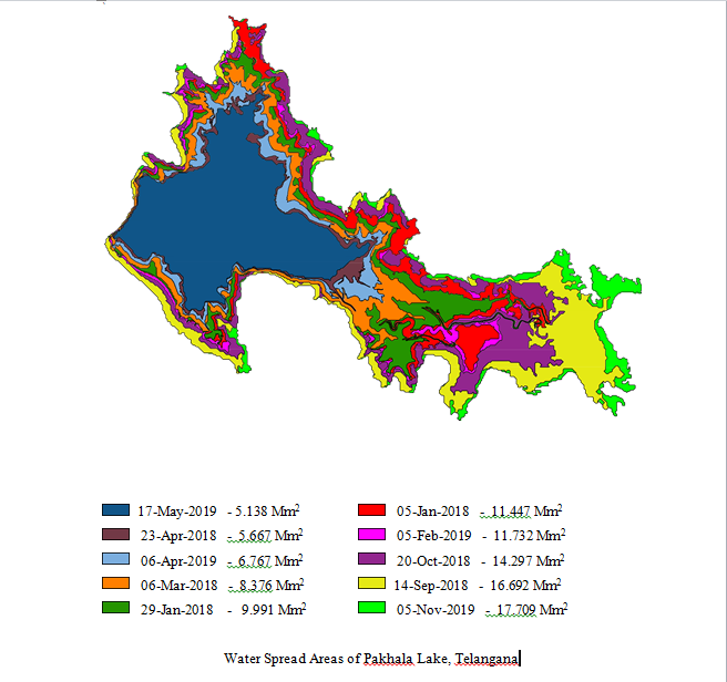
Capacity evaluation of Pakhala lake, Warangal Rural Dist. by using Remote Sensing Techniques (during 2019-20).
Preparation of FRL Contour plan and Contour imageries of Wyra reservoir, Khammam Dist. by using IRS Resourcesat-2, LISS-IV Satellite data (during 2018-19).
Preparation of FRL Contour plan and Contour imageries of Ookachettivagu reservoir, Khammam Dist. by using IRS-P6, LISS-III Satellite data (during 2015-16).
Preparation of FRL Contour plan of Nallavagu reservoir, Sanga Reddy Dist. by using IRS-P6, LISS-III Satellite data (during 2015-16).
Preparation of FRL Contour plan of Singotam reservoir, Mahabubnagar Dist. by using Resource Sat-II, LISS-IV, FMX Satellite data (during 2015-16).
1. INTRODUCTION
The Remote Sensing Laboratory was established in the year 1986 vide the G.O.Ms.No.62 Dt: 11.2.1986 Irrigation (IRR VII) Department to cater the needs of Irrigation Department. This Lab is taking up the works like estimation of capacity of reservoir and the rate of sedimentation, identification of ground water potential zones, crop land acreage estimation under command areas and other related problems for water resources development and management studies.
2. INFRASTRUCTURE
Previously analysis was carried out with the visual interpretation equipments like Multispectral Additive Color Viewer, Optical Reflecting Projector, PROCOM-II instrument, Image Analyzer, Digital Planimeter, Digital Curvimeter etc. At present Earth Resource Data Analysis System (ERDAS) Imagine software, QGIS are used for the Geospatial analysis of data.
3. METHODOLOGY TO BE FOLLOWED
To evaluate the capacity of reservoir, the cloud free satellite data at a selected reservoir level is procured. Digital analysis is carried out for identifying the water pixels and for determining the water spread area.
Water is one of the most easily delineable features on the satellite data due to high contrast between land and water boundaries in Near Infrared Band (NIR), wherein water absorbs almost entire incident energy depending on nature and status of water body while land features absorb less depending on cover type, roughness, composition etc.
In multispectral image, each pixel has a spectral signature determined by the reflectance of that pixel in each of the spectral bands. Multi-spectral classification is an information extraction process that analyses the spectral signature and then assigns pixels to the classes based on similar signatures. Classification procedures attempt to group together such similar pixels so that a thematic layer can be generated with each land cover type represented by a different class. The detail of the class depends on the spectral and spatial resolution characteristics of the imaging system.
The Image Classification techniques used in Remote Sensing are
- Unsupervised method
- Supervised method
UNSUPERVISED CLASSIFICATION
Unsupervised classification is a form of pixel based classification and is essentially computer automated classification. The user specifies the number of classes desired and a confidence threshold. Clustering algorithms are used to determine the natural statistical grouping of data. After the clusters are built, the analyst must select the land cover classes (water, vegetation etc.,) and then assign each cluster to the appropriate class. For this, it is important that the user shall have a good knowledge of the region being mapped to decide the land cover which the pixels of each cluster represent. Once all the clusters have been assigned to a class, the image of clusters can be recorded into a thematic layer, which displays each land cover class with a different colour.
SUPERVISED CLASSIFICATION
Supervised image classification is a procedure for identifying spectrally similar areas on an image by identifying training sites of known targets and then extrapolating those spectral signatures to other areas of unknown targets. The computer determines the spectral signature of the pixels within each training area, and uses this information to define the statistics, including the mean and variance of each class.
4. IMPORTANT WORKS DONE
Since the inception of this Laboratory, several works such as estimation of present capacity of major and medium type of reservoirs in combined state of Andhra Pradesh, crop land acreage estimation under Nizamsagar command area, identification of ground water potential zones in Ranga Reddy district, change detection studies in Krishna River upstream of Prakasham barrage and also rainfall run-off studies in Palair sub-basin etc., were carried out.
4.1 Works in the recent past
Capacity evaluation of Pakhala lake, Warangal Rural Dist. by using Remote Sensing Techniques (during 2019-20).
Preparation of FRL Contour plan and Contour imageries of Wyra reservoir, Khammam Dist. by using IRS Resourcesat-2, LISS-IV Satellite data (during 2018-19).
Preparation of FRL Contour plan and Contour imageries of Ookachettivagu reservoir, Khammam Dist. by using IRS-P6, LISS-III Satellite data (during 2015-16).
Preparation of FRL Contour plan of Nallavagu reservoir, Sanga Reddy Dist. by using IRS-P6, LISS-III Satellite data (during 2015-16).
Preparation of FRL Contour plan of Singotam reservoir, Mahabubnagar Dist. by using Resource Sat-II, LISS-IV, FMX Satellite data (during 2015-16).
